
Methodology
Developping fast and robust coastal flooding models accounting for processes complexity and cascade effect is a challenge. The solution explored in RISCOPE relies on meta-models, i.e. mathematical functions which estimate with good precision and at a negligible computational cost (<minutes) the results which could be obtained with the numerical model. An early-warning oriented demonstrator will be set up using the developed meta-models and local data (offshore conditions, GIS data, etc.) and the user interface will be designed with decision makers. It will be used in a forecast/warning mode (few days), but also in a scenario mode. This scenario mode will be used to raise risk-awareness (simulations performed during workshops) and to estimate coastal flooding hazard return periods and associated uncertainties, under present and future climate. To develop the method and the demonstrator, the site of Gâvres (Morbihan) has been selected as it is representative of a significant part of French mainland coasts in terms of variety and complexity of flooding processes, as well as available offshore data.
Programme
To reach its objectives and address the different challenges, RISCOPE gathers a multidisciplinary team of statisticians, oceanographers, GIS and Decision Support System experts. The work and the related research activities is organized in 6 WP’s.
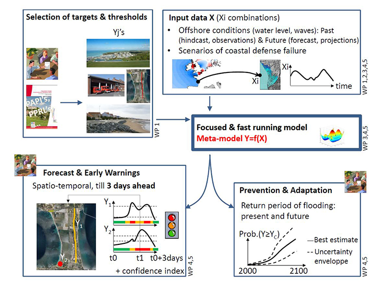
WP1 (site analysis) will characterize the study site, i.e. Gâvres, in terms of past flooding events, vulnerability, existing coastal flooding risk practices and needs.
WP2 (full-process based modeling) will provide a validated and robust process based model. This model will be used to build a flood database for the meta-model construction.
WP3 (meta-modeling) will provide a fast running model to replace the long-running computer code describing accurately the complex space-time processes of flooding.
WP4 (early-warning oriented demonstrator) will provide a user-friendly demonstrator, running on personal computer, with two user modes: forecast & early warning and scenario.
Finally WP5 (performance assessment for operational use) will use the demonstrator under three angles: coastal flooding prediction and early warning skills, assessment of coastal flooding hazard and of the potential effect of climate change. It will also compare the results with traditional approaches, make a critical analysis, and provide guidelines for the application of the developed method in other areas.
WP2&3 are the core of the project. This core relies on the preliminary site analysis (WP1) and will be the basement for achievement of WP4&5. WP0, dedicated to project coordination and dissemination, will guarantee a good communication and regular interactions between WP’s through meetings and work sessions.

